When travelers speak about Vietnam, they often mention its contrasts—and nowhere is this more evident than in North Vietnam. This region, located in the northernmost part of the country, is not only the geographical cradle of Vietnamese civilization but also a place where nature, history, and daily life are deeply intertwined. Known in Vietnamese as Bắc Bộ, North Vietnam has carried many names throughout history, including Bac Trieu, Dang Ngoai, Bac Ha, Bac Thanh, Bac Ky, and Bac Phan—each reflecting a different political or cultural chapter.
You May Also Like:
Traveling through North Vietnam is less about ticking off landmarks and more about absorbing atmospheres. From mist-covered mountains to ancient deltas shaped by rivers, from stone villages to bustling cities, the region unfolds slowly, revealing layers rather than spectacles.
The Geographic Identity of North Vietnam
North Vietnam’s landscape slopes gradually from the rugged highlands of the northwest down toward the eastern coastline, following the flow of major river systems. This natural gradient has shaped settlement patterns, agriculture, trade routes, and even cultural identities across centuries.
Geographically, North Vietnam is commonly divided into three major subregions:
- The Northwest (Tây Bắc Bộ)
- The Northeast (Đông Bắc Bộ)
- The Red River Delta (Đồng bằng sông Hồng)
Today, North Vietnam consists of 25 provinces and centrally governed cities, each contributing to the region’s diversity while remaining connected by shared history and climate.
From a traveler’s perspective, this division is not merely administrative—it defines how North Vietnam feels, moves, and lives.
Northwest Vietnam: Where Mountains Shape Life
First Impressions of Northwest Vietnam
Entering Northwest Vietnam feels like stepping into a vertical world. Roads climb steadily into mountains, valleys open suddenly, and clouds seem close enough to touch. This subregion lies between the Hoang Lien Son mountain range and the Ma River basin, bordering both Laos and China.
The Northwest includes six provinces: Lao Cai, Lai Chau, Yen Bai, Dien Bien, Son La, and Hoa Binh. Together, they cover more than 5.6 million hectares and are home to around 4.5 million people—many of whom belong to ethnic minority groups.
Geography and Natural Resources
Northwest Vietnam is dominated by high mountains running northwest to southeast. The Hoang Lien Son range towers above the region, with peaks rising between 2,800 and 3,000 meters, including Mount Fansipan—the highest point in Indochina. Between these ranges lie river basins such as the Da River and high plateaus like Moc Chau and Na San.
This dramatic terrain gives Northwest Vietnam immense natural wealth. The region is rich in minerals—copper, lead, zinc in Son La, and rare earth elements in Lai Chau—making it strategically important for resource extraction. Vast forest cover supports forestry, medicinal plants, and biodiversity conservation.
Hydropower is another defining feature. Massive rivers flowing through steep valleys have enabled large-scale hydroelectric projects, supplying energy far beyond North Vietnam itself.
Challenges and Realities
However, travel through Northwest Vietnam also reveals its challenges. The rugged topography makes infrastructure development difficult. Roads are narrow and winding, landslides are common during the rainy season, and remote villages can feel isolated.
Natural disasters—flash floods, landslides, earthquakes, whirlwinds, and hailstorms—regularly affect daily life. These realities shape a resilience that becomes evident when interacting with local communities.
Culture and People
Northwest Vietnam is culturally rich, home to ethnic groups such as the Thai, Muong, Hmong, Dao, Tay, and Kinh. Each community contributes distinct traditions, clothing, music, and festivals. The Thai Xoe dance, for example, is not performed for tourists alone—it remains a living expression of communal life.
Travelers often find that the true highlight of Northwest Vietnam is not a viewpoint or a trail, but shared moments: a meal in a wooden house, a market morning, or a quiet evening overlooking terraced fields.
Northeast Vietnam: Where Stone, Climate, and History Converge
Understanding Northeast Vietnam
While often grouped under the broader “northern mountains,” Northeast Vietnam has its own geographic and cultural identity. Located north and northeast of Hanoi, the region extends toward the Chinese border and the Gulf of Tonkin.
The Northeast consists of nine provinces: Ha Giang, Cao Bang, Bac Kan, Lang Son, Tuyen Quang, Thai Nguyen, Phu Tho, Bac Giang, and Quang Ninh. With a total area of approximately 5.66 million hectares, it accounts for nearly 9% of Vietnam’s landmass and is home to over 9 million people.
Distinctive Terrain and Climate
Unlike the linear mountain ranges of the northwest, Northeast Vietnam is characterized by arc-shaped mountain chains radiating toward the Tam Dao range. Limestone plateaus, deep valleys, and karst formations dominate the landscape.
The region lies firmly within the tropical monsoon climate zone, but the influence of the northeast monsoon creates stark seasonal contrasts. Winters can be harsh—particularly in highland provinces such as Ha Giang, Cao Bang, and Lang Son, where temperatures may drop below freezing and occasional snowfall or frost appears.
Summers, by contrast, are relatively mild, giving Northeast Vietnam a humid subtropical character. These climatic conditions shape agriculture, architecture, and daily routines.
Travel Experience
Traveling through Northeast Vietnam often feels raw and elemental. Stone fences line winding roads, villages cling to mountainsides, and life adapts to the terrain rather than reshaping it.
The region is also home to some of North Vietnam’s most iconic landscapes, including karst plateaus, deep river gorges, and remote borderlands where history and geography intersect.
The Red River Delta: The Cultural and Economic Core of North Vietnam
The Delta Experience
Descending from the mountains into the Red River Delta, travelers encounter a completely different rhythm. This is the historical heart of North Vietnam, where rivers slow, land flattens, and human settlement becomes dense and continuous.
The Red River Delta includes 11 provinces and cities: Hanoi, Hai Phong, Quang Ninh, Hai Duong, Hung Yen, Vinh Phuc, Bac Ninh, Ha Nam, Nam Dinh, Ninh Binh, and Thai Binh.
Geography and Infrastructure
Formed by centuries of sediment from the Red River and Thai Binh River systems, the delta is low-lying and fertile. Its dense network of rivers and canals supports agriculture, transport, and industry, but also creates seasonal challenges.
During the rainy season, rivers swell and flooding becomes a constant concern. In the dry season, water shortages can affect farming and daily life. These cycles have shaped sophisticated water management systems and communal cooperation.
Economic and Social Significance
The Red River Delta is Vietnam’s most densely populated region and a major economic engine. Flat terrain and strategic location have enabled rapid urbanization, industrial development, and infrastructure growth.
The labor force here is large, skilled, and diverse, supporting manufacturing, services, logistics, and innovation. Yet despite modernization, traditional village structures, communal houses, and festivals remain deeply embedded in daily life.
Natural Characteristics of North Vietnam
Diverse Terrain
North Vietnam’s geography is remarkably varied. From fertile deltas to towering mountains and limestone plateaus, each subregion influences economic activity, settlement patterns, and environmental challenges.
- The Red River Delta supports intensive rice cultivation and urban expansion.
- The Northern Highlands provide minerals, forests, and eco-tourism potential.
- The Northeast combines karst landscapes with biodiversity conservation and mining.
River Systems
Rivers are central to life in North Vietnam. The Red River and Thai Binh River systems provide irrigation, transportation, and hydroelectric power. Lakes such as Ba Be and Thac Ba play vital ecological and economic roles while supporting tourism and conservation.
Climate and Seasons
North Vietnam experiences a distinct four-season climate:
- Spring: Mild, humid, ideal for agriculture.
- Summer: Hot, rainy, occasionally extreme.
- Autumn: Cool, dry, and widely regarded as the best travel season.
- Winter: Cold and dry, particularly in mountainous areas.
These seasonal shifts affect everything from crop cycles to festivals, making North Vietnam a region where time is strongly seasonal.
Natural Resources and Environmental Value
North Vietnam is rich in natural resources:
- Minerals: Coal in Quang Ninh; iron, copper, and gold elsewhere.
- Forests: Providing timber, medicinal plants, and wildlife habitats.
- Soils: Fertile alluvial land in the Red River Delta.
- Water Resources: Rivers, lakes, and reservoirs sustaining ecosystems and livelihoods.
This abundance gives North Vietnam strong development potential, but also underscores the importance of sustainable management.
A Traveler’s Map of North Vietnam: Iconic Destinations That Define the Journey
Traveling through North Vietnam is less about following a checklist and more about tracing a rhythm—one shaped by history, landscape, and everyday life. Each destination in North Vietnam feels distinct, yet they are bound together by shared cultural roots and geographical continuity. From bustling urban streets to mist-covered mountains and quiet river valleys, North Vietnam offers a layered travel experience that rewards time, curiosity, and attention.
Rather than overwhelming visitors with spectacle, North Vietnam invites them to slow down. The following destinations—Hanoi, Sapa, Ha Long Bay, and Ninh Binh—form a natural travel map through the region. Together, they illustrate why North Vietnam remains one of Southeast Asia’s most compelling and emotionally resonant destinations.
Hanoi: The Living Capital of North Vietnam
Hanoi is not simply the political capital of Vietnam; it is the cultural and historical heartbeat of North Vietnam. The city does not announce itself loudly. Instead, it reveals its character gradually—through street corners, morning routines, and the quiet persistence of tradition amid constant movement.
Walking through Hanoi feels like moving through layers of time. Ancient pagodas stand calmly beside French colonial villas, while modern glass buildings rise discreetly in the background. The Temple of Literature, Vietnam’s first national university, reflects the Confucian foundations that shaped North Vietnam’s intellectual history. Its stone steles and courtyards speak of centuries when education and moral discipline defined social mobility.
Hoan Kiem Lake, located at the city’s center, functions as Hanoi’s emotional core. At dawn, elderly residents practice tai chi by the water, while office workers pass by on their way to work. By evening, the lake becomes a shared public living room where locals walk, talk, and pause. This daily cycle encapsulates the spirit of North Vietnam—communal, measured, and deeply rooted in routine.
The Old Quarter offers another perspective. Its narrow streets, originally organized by trade guilds, remain dense with activity. Each street carries both its name and its legacy—silk, silver, paper, herbs. Motorbikes weave through crowds, vendors call out softly, and cafés spill onto sidewalks. It is chaotic, yet deeply familiar, reflecting the resilience and adaptability that define urban life in North Vietnam.
Hanoi’s cuisine is inseparable from its identity. Dishes such as pho, bun cha, and banh cuon are not merely meals; they are daily rituals. Sitting on a low plastic stool, eating pho from a steaming bowl on a cool morning, feels less like tourism and more like participation. Food in Hanoi—and in North Vietnam as a whole—is intimate, affordable, and deeply tied to place.
Despite its size and pace, Hanoi never feels detached from its past. It is a city that lives forward while remembering backward, making it the perfect starting point for any journey through North Vietnam.
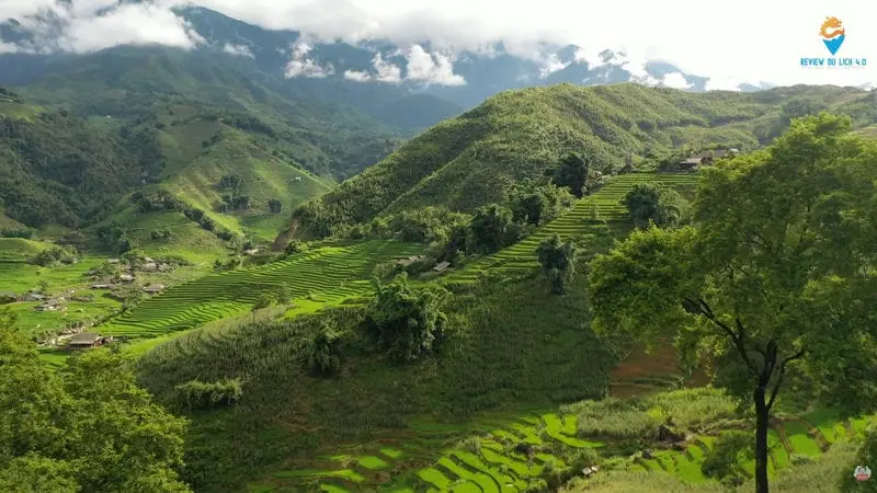
Sapa: Highlands, Heritage, and the Vertical Landscape of North Vietnam
Leaving Hanoi and traveling northwest, the terrain begins to rise, and the air grows cooler. This transition marks entry into one of the most visually striking regions of North Vietnam: Sapa and its surrounding highlands.
Located in Lao Cai Province near the Chinese border, Sapa sits at an altitude that gives it a climate unlike most of Vietnam. Mist often drapes the mountains, and temperatures remain cool even in summer. This environment has shaped both the landscape and the culture of the region.
Sapa is best known for its terraced rice fields, carved meticulously into steep mountainsides. These terraces are not only agricultural structures but also cultural artifacts—evidence of generations adapting to difficult terrain with patience and precision. During planting season, the fields reflect the sky like mirrors. During harvest, they glow gold, transforming the hills into living mosaics.
Ethnic diversity is central to the Sapa experience. Hmong, Dao, Tay, and Giay communities inhabit villages scattered across valleys and slopes. Each group maintains distinct clothing, languages, and customs. Visiting villages such as Cat Cat or Ta Van offers more than scenic beauty; it provides insight into how life in North Vietnam adapts to geography rather than reshaping it.
Hiking is one of the most meaningful ways to experience Sapa. Trails pass through rice fields, bamboo forests, and small settlements where daily life continues uninterrupted by tourism. Children walk home from school, farmers tend water buffalo, and smoke rises from kitchens at dusk. These moments reveal a quieter side of North Vietnam—one defined by continuity and connection to land.
Mount Fansipan, known as the “Roof of Indochina,” rises above the region at 3,143 meters. Whether reached by cable car or on foot, its summit offers expansive views that emphasize the scale and complexity of North Vietnam’s mountainous geography. Yet even here, the experience feels contemplative rather than triumphant.
Sapa is not simply a destination; it is a reminder that North Vietnam’s identity is inseparable from its highlands and the people who inhabit them.
Ha Long Bay: Where Stone Meets Sea in North Vietnam
If Sapa represents North Vietnam’s vertical landscape, Ha Long Bay represents its horizontal vastness. Located in Quang Ninh Province along the Gulf of Tonkin, Ha Long Bay is one of the most iconic natural landscapes in all of North Vietnam—and one of the most recognizable images of Vietnam globally.
Designated a UNESCO World Heritage Site, Ha Long Bay is defined by thousands of limestone karsts rising dramatically from emerald waters. These formations, shaped over millions of years, create a seascape that feels both monumental and intimate.
Traveling through Ha Long Bay is best experienced by boat. As the shoreline recedes, the bay opens into a labyrinth of islands, caves, and hidden lagoons. The movement is slow and deliberate. Limestone towers drift past, their reflections shimmering on the water’s surface.
Kayaking allows closer interaction with the landscape. Paddling through narrow passages into sheltered coves reveals quieter corners of the bay, where silence dominates and the scale of the formations becomes more personal. Inside caves such as Sung Sot or Thien Cung, light filters through openings, illuminating stalactites and chambers carved by time.
Despite its popularity, Ha Long Bay retains a sense of calm—especially in the early morning or late afternoon, when mist softens the outlines of the karsts. These moments reveal why Ha Long Bay holds such significance within North Vietnam: it is not only visually impressive, but also emotionally grounding.
Beyond its beauty, Ha Long Bay reflects North Vietnam’s close relationship with water. Fishing villages, floating houses, and maritime traditions speak to centuries of life shaped by tides and seasons. Even as tourism grows, these cultural layers remain present beneath the surface.
Ninh Binh: A Quiet Masterpiece of North Vietnam
South of Hanoi lies Ninh Binh, a destination often described as “Ha Long Bay on land.” While the comparison is useful, it does not fully capture the character of this region within North Vietnam. Ninh Binh is quieter, more contemplative, and deeply connected to both nature and spiritual history.
The landscape of Ninh Binh is defined by limestone karsts rising from flat river valleys. Unlike the sea-bound formations of Ha Long Bay, these karsts emerge from rice fields and waterways, creating a uniquely pastoral setting. Rivers wind slowly through the terrain, and boat travel replaces roads as the primary way to explore.
Trang An, a UNESCO World Heritage Site, is the most renowned attraction in Ninh Binh. Drifting through its waterways in a small boat feels meditative. The route passes through caves, open valleys, and temple sites nestled at the base of cliffs. The silence is broken only by water against oars and the occasional echo within caves.
Tam Coc–Bich Dong offers a similar experience with a more rural atmosphere. During rice season, the fields lining the river turn golden, and farmers work alongside passing boats. This coexistence of daily life and natural beauty defines much of North Vietnam’s charm.
Spiritual landmarks add another dimension. Bai Dinh Pagoda, one of the largest Buddhist complexes in Southeast Asia, stands as a testament to the enduring role of spirituality in North Vietnam. Its scale is impressive, but its setting—surrounded by mountains and open sky—encourages reflection rather than spectacle.
What makes Ninh Binh particularly appealing to travelers is its pace. There is no urgency here. Days unfold slowly, allowing time to observe, walk, and absorb. For those seeking depth rather than drama, Ninh Binh represents North Vietnam at its most poetic.
North Vietnam as a Continuous Experience
Taken together, Hanoi, Sapa, Ha Long Bay, and Ninh Binh form more than a collection of destinations. They create a narrative—a journey through the physical and cultural landscapes of North Vietnam.
Hanoi provides context and continuity. Sapa offers altitude and heritage. Ha Long Bay introduces scale and natural wonder. Ninh Binh brings stillness and balance. Each place complements the others, reflecting different aspects of North Vietnam’s identity.
For travelers, this region does not demand constant movement. Instead, it rewards those who pause, observe, and engage. North Vietnam is not a place to rush through—it is a place to experience gradually, allowing its rhythm to set the pace.
Why North Vietnam Stays With You
What sets North Vietnam apart is not just its landscapes or landmarks, but its depth. This is a region that invites patience, curiosity, and respect. It does not reveal itself instantly, but rewards those who travel slowly.
From misty mountains to river-fed plains, from ancient capitals to remote villages, North Vietnam is less a destination than a continuous experience—one shaped by geography, history, and human resilience.